|
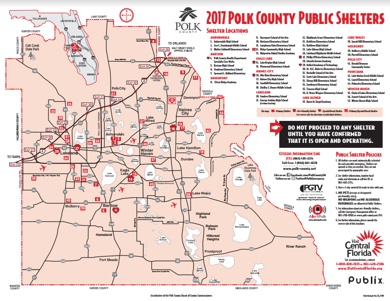
In preparation for hurricane season, which begins on June 1, Polk County Tourism and Sports Marketing and Polk County Emergency Management have again partnered with Publix Super Markets to produce and distribute the "Polk County Public Shelters" maps for 2017. This annual map is designed to assist both resident and tourist evacuees in finding shelter during an impending storm. “In the event a hurricane threatens Central Florida, we will work closely with our accommodations partners to determine the supply of available accommodations. This information is critical in helping evacuees find available lodging. We want our guests to have a safe and pleasant experience, in spite of the circumstances," said Mark Jackson, director of Polk County Tourism and Sports Marketing (PCTSM). PCTSM relays this vital information to Polk County Emergency Management (PCEM) and area lodging facilities. PCEM uses this data to decide when and where to open shelters, once area accommodations reach capacity. Evacuees can then be directed to open shelters using the "Polk County Public Shelters" map, which lists shelter locations on one side and directions to those shelters on the other. The map also provides sources of emergency information, important telephone numbers and a list of recommended items to include in a “3-Day Survival Kit”. The 2017 map includes 47 shelters, three of which are designated as “Special Needs Shelters”, for residents with medical or physical conditions that would require special assistance during an emergency. Pre-registration is recommended, by contacting Polk County Emergency Management at 863-298-7027. Three additional shelters have been designated as “Pet Friendly”, with pets being limited to dogs, cats and birds only. Specific requirements apply at “Pet Friendly” shelters, so it is advised to check those requirements in advance. It should be noted that not every shelter may be opened during a particular storm, so evacuees are advised to confirm that a specific shelter has been activated prior to going there. The public shelters maps are available at Central Florida’s Visitor Information Center, located at 101 Adventure Court, Davenport, FL, ½ mile south of I-4 on Highway 27; and at Publix Super Markets in Polk County by the end of May. The map, printed in red this year, contains updated information for 2017. Businesses and residents are advised to discard older maps of different colors. Area lodging facilities and chambers of commerce have also received a supply of maps to keep on hand for distribution to evacuees in the event of a storm. A copy of the map is available online at www.polk-county.net/prepare - scroll down and click on 2017 Hurricane Shelter Map. For more information about emergency preparedness in Polk County, visit www.polk-county.net/em. Below is a list of Polk County Public Shelters and the directions to those locations.
3 Comments
Nancy Odell
9/6/2017 06:31:24 am
Can you tell me if there is a pet friendly shelter in Winter Haven. Thank you.
Reply
Katie
9/6/2017 06:37:47 am
Nancy,
Reply
Lizbeth Ramirez
9/7/2017 03:45:54 pm
What are the requirements if we take our pets with us?
Reply
Your comment will be posted after it is approved.
Leave a Reply. |
||||||
Upcoming Events |
|


