|
Provided by: City of Winter Haven – Natural Resource Division What is Hydrology?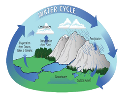 Hydrology is the study of water and how it interacts with our environment. This field of science is important for us to understand where our water comes from, how it affects the Winter Haven area as well as how we, as a society, impact our water resources. Hydrological changes can influence other aspects of our natural resources such as water quality and local ecology in our lakes and wetlands. That is why the City Natural Resources Division (NRD) monitors hydrology as part of its overall management strategy. RainfallThe Winter Haven area is a purely rainfall driven hydrologic system—meaning that all of our surface and groundwater originates from precipitation rather than water flowing from upstream. Winter Haven’s lakes are the headwaters of the Peace River which flows through Charlotte Harbor, terminating in the Gulf of Mexico. So the amount of rain we receive affects everyone downstream all the way to the ocean. The NRD relies on an expanding network of sensors and radar data to monitor rainfall across the City. Weather stations have been deployed at several locations throughout the City with more being added regularly. The data from these stations are available to the public via wunderground.com. The NRD also utilizes Next-Generation Radar (NEXRAD) data, which is hosted by the Southwest Florida Water Management District, to create grid maps for the Winter Haven area (see NEXRAD Map). These maps grant a comprehensive view of localized rainfall over a large area that help to fill in the gaps between rain gauges. Multiple data sources provide a more accurate representation of average rainfall for the City than if only a single source is used. This data is then analyzed by the NRD to draw conclusions, make comparisons, and draft reports like this. 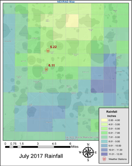 August Rainfall ReportDuring the month of August, the Winter Haven area accumulated a total of 5.50 inches of gross rainfall averaged from rain gauges located at Waste Water Treatment Plants 1 & 2, the Florida Automated Weather Network station in Lake Alfred, and the two calibrated City weather stations located at City Hall and Motor Pool. In order to understand how to balance the water budget, we must correct for water loss via evaporation and plant uptake (evapotranspiration). The resulting value represents Winter Haven’s net rainfall which totaled 0.09 inches for the month. In conclusion, the City essentially broke even in August while, at the same time, retained a rainfall deficit of -5.97 inches in 2017 (YTD Net Rainfall). This information is visualized in Figure 1. In order to gain perspective on rainfall this month, we must compare 2017 values with historic data collected from 1915 to the present. Looking at Figure 2, we can see that rainfall for August 2017 totaled below the long-term average (Average 1915-2016) and just barely reached the low end of the normal range for this month. While we did receive less than precipitation than we hoped this August, we are expecting a considerable increase in accumulated rainfall for the month of September with the arrival of Hurricane Irma. 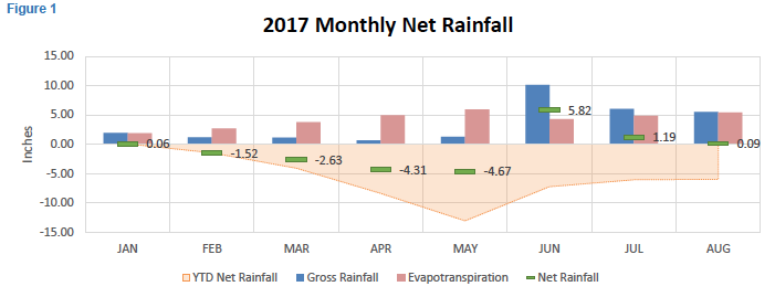 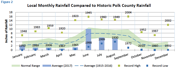 Lake LevelsWinter Haven’s lakes are some of our most economically and ecologically important natural resources; with visitors coming from across the globe to live the lake life. Therefore, it’s important for the NRD to monitor surface levels not only to ensure they are usable, but because water quality is strongly associated with the volume of water in the lakes. Since Winter Haven is a purely rainfall driven system, the amount of precipitation we receive can impact things like wetland connectivity and nutrient concentrations. Winter Haven has approximately 50 lakes, so monitoring the level of each one presents challenges. However, the 14 lakes on the Southern Chain are all connected via canals and surface levels are equalized. Since the Southern Chain spans a large area of the City, its surface level is generally representative of the region. Partnering with the Lakes Region Lakes Management District, the NRD compiles daily staff gauge readings on Lake Shipp to calculate monthly surface level averages for the Southern Chain. We can then compare surface levels to previous months as well as long-term levels. August Surface Level Report Average surface level (SL) for the Southern Chain of Lakes was reported at 130.43 feet above sea level for the month of August. This was a slight increase over the July’s average SL at 130.20 ft. Looking at Figure 3, we can see that lake levels hovered above the long-term average (Avg Surface Level [1987-2016]) for the first few months in 2017. Due to lack of rainfall, lake levels decreased to below average, but still within the normal range. The onset of the wet season has elicited a gradual increase in lake levels. However, we can expect to see a significant increase in SLs in September due to rainfall from Hurricane Irma. 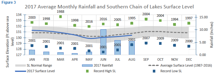 Questions?The Winter Haven Natural Resources Division is dedicated to the protection of our natural resources. This includes educating the public. If anyone has any questions regarding the content of this report, please feel free to contact Devon Moore or anyone in the NRD team.
Devon Moore Environmental Scientist I 863-291-5600 x247 [email protected]
0 Comments
Your comment will be posted after it is approved.
Leave a Reply. |
Upcoming Events |
|